4 Weather Systems in 6 Days

OVERVIEW
An
active weather pattern is expected to set up for next week resulting in several
storm systems potentially impacting the area.
______________________
WEATHER IMPACTS
Clark, Lincoln, Nye,
Esmeralda, Inyo, San Bernardino and Mohave Counties
HIGH Confidence Pattern change taking place next week.
LOW Confidence Timing and strength of separate
storm systems, precipitation amounts and exact snow levels.
______________________
FORECAST DETAILS
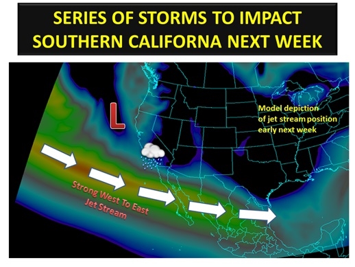
A
shift in the main storm track is expected to finally take place early next
week. This is more typical of the storm track during an El Niño episode in
which the main storm track is aimed at southern California and Arizona. A
series of storm systems is expected to work across the area during this time
frame. As stated above, confidence is low in the exact timing and strength of
these storm systems as well as exact precipitation amounts and snow levels.
Monday Morning-Monday
Night
●
First storm system possible.
●
Some models take this storm directly south of all or much of the area,
therefore at this time the best chance of showers will be in San Bernardino,
Mohave and southern Clark Counties.
Tuesday-Wednesday
●
Likely to be a bigger precipitation event for the entire area compared to the
Monday system.
●
May be one defined storm or two separate systems, thus precipitation could be
spread out over a longer period or in shorter breaks.
●
This system may have a tap of better moisture with it, which could bode well for
heavier precipitation amounts.
Friday-Saturday
●
At this time, this is expected to be a system that approaches from the
northwest, which would favor a colder storm with less moisture to work with.
This would result in lower snow levels compared to the above two storms.
● Trajectory of this
system could result in some areas seeing no precipitation at all, but still
experience clouds and wind.